Garmin BlueChart® g3 Vision® HD - VCA019R - Hecate Strait - microSD™/SD™
Rated 3/5
based on 1 customer reviews
by Joitos.com,
Be the first one to review this product.
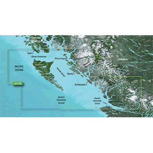
p strong BlueChart reg g3 Vision reg HD - VCA019R - Hecate Strait - microSD trade SD trade strong p p strong Coverage strong p p Hecate Strait and the surrounding waters specifically Hecate Island the British Columbia coast from Prince Rupert to Port Hardy Queen Charlotte Sound Dixon Entrance to Duke Island FitzHugh Sound Dean Fisher Channel Burke Channel Whale Channel Barrie Reach Kitimat Arm Grenville Channel Portland Inlet to the Nass River Port coverage includes Port Hardy Kitimat and Bella Bella p p strong Premier Coastal Charts strong p ul li Industry-leading coverage clarity and detail with updated coastal charts that feature integrated Garmin and Navionics reg content li li Auto Guidance sup1 technology quickly calculates a suggested route by using your desired depth and overhead clearance li li Includes Depth Range Shading for up to 10 depth ranges enabling you to view your target depth at a glance li li Up to 1 rsquo contours provide a more accurate depiction of the bottom structure for improved fishing charts li li To give a clear picture of shallow waters to avoid the Shallow Water Shading allows for shading at a user-defined depth li ul p Experience unparalleled coverage and brilliant detail when you rsquo re on the water BlueChart g3 Vision coastal charts provide industry-leading coverage clarity and detail with integrated Garmin and Navionics content p p strong Auto Guidance strong p p Whether you are fishing or cruising select a spot and get a route showing you the general path and nearby obstructions at a safe depth sup 1 sup p p strong Depth Range Shading strong p p This feature displays high-resolution Depth Range Shading for up to 10 depth ranges so you can view your designated target depth p p strong Shallow Water Shading strong p p To give a clear picture of shallow waters to avoid this feature allows for shading at a user-defined depth p p strong Detailed Contours strong p p BlueChart g3 Vision charts feature 1 rsquo contours that provide a more accurate depiction of bottom structure for improved fishing charts and enhanced detail in swamps canals and port plans p p strong High-resolution Satellite Imagery strong p p High-resolution satellite imagery with navigational charts overlaid gives you a realistic view of your surroundings It rsquo s our most realistic charting display in a chartplotter mdash ideal for entering unfamiliar harbors or ports p p strong FishEye View strong p p This underwater perspective shows 3-D representation of bottom and contours as seen from below the waterline Interface with sonar data for a customized view p p strong MarinerEye View strong p p This view provides a 3-D representation of the surrounding area both above and below the waterline p p strong Aerial Photography strong p p Crystal-clear aerial photography shows exceptional detail of many ports harbors and marinas and is ideal when entering unfamiliar ports p p sup1 Auto Guidance is for planning purposes only and does not replace safe navigation practices p p img src https productimageserver com prop65 6pt png alt Warning strong WARNING strong This product can expose you to chemicals which are known to the State of California to cause cancer birth defects or other reproductive harm For more information go to a href P65Warnings ca gov P65Warnings ca gov a p --- cis2 mmxtmJVt --- br
No Reviews Yet